Yes, I’m finally off Vancouver Island, poking around British Columbia as the first leaves start to turn yellow. I look back at this year’s trip and can’t really make sense of it. My plans totally changed, multiple times, and yet I did still have a goal that I accomplished. In the wider context though — of trying to define purpose and meaning — I’m still wandering in the real and figurative sense.
But what I can say is I got to see some new things, long enough that seeing new things became old. This is the circular nature of trying to apply meaning to a world as vast as a human life. People find meaning in their work or their family, or they just plant a damned garden or volunteer at the food bank. I have to get all existential, so the result is correlate to the effort.
But that’s not the purpose of this post. I’m here to update on my travels and share some photos. Last installment I was in the Uculet and Tofino area. The road back was the same one in, which certainly wasn’t the end off the world. Hwy 4 travels through wonderful country, with mountain views, tight curves, massive lakes, and only falls short in its lack of passing opportunities when you get stuck behind a slow vehicle.

I was feeling exhausted though and made it a short day by stopping in the town of Port Alberni where there was a cheap motel. It was pretty old and musty but not roach-infested, so I made the most of it, staying there four nights simply because I couldn’t muster the energy to go somewhere else. I hadn’t ever really cured the bout of lethargy that hit me back in July, and it seemed like another wave was coming on.
There isn’t much to do about it except go through the motions though, so eventually I picked another destination and went there. Since there’s no route down the west side of the island, I went back to Hwy 19 and down to Hwy 18, which heads toward Lake Cowichan.
From there you turn south and towards Port Renfrew. The Pacheedaht Reserve is there in a large bay and has a decent campground with showers and laundry as well as a small store. I booked four nights knowing I wasn’t much in the mood to pack up and travel any time soon. While things were pretty cold and breezy on the bay, the views were fantastic.

I started out by just riding around and finding dinner, then finding the local store (which closes pretty early) so I could get some groceries for the next few days. I also back-tracked a bit to Fairy Lake, because there’s a tree growing out of a submerged tree trunk that looks like a bonsai tree. Some people even call it The Fairy Lake Bonsai.
I got some pictures but was a little late to nail the golden hour, and got a more gray-ish light, but a very calm water surface.


After that I went in search of another famous tree, Big Lonely Doug. Doug is an old-growth Douglas Fir that was left behind when loggers came through the area a hundred years ago. He isn’t as lonely as he sounds though, as there are a few smaller old-growth firs within shouting distance as well as an entire forest of younger trees and underbrush.
Add to it that he is on Google Maps, and there are plenty of humans coming to visit Doug every day. Honestly, he would probably ask for privacy if he were any other tree; I don’t feel like trees are used to much company aside from the occasional bird nest.


The thing was gorgeous though. I could get within about a half-mile of the trail before 4WD was required, so the hike itself was short, but steep. Doug is so big I missed him as I approached. I saw the tree at a distance but the top is about level with the road used as the first part of the hike.
The trail down is so steep and the trees so thick that I was focused on my footing. I thought I still had a ways to go when I rounded a curve in the trail, and poof…there he was. It was hard to understand the size of the thing and of course was even harder to photograph; when you are far enough back to shoot the whole tree it looks small because of the distance, but close up you can’t fit it into the frame of the photo.
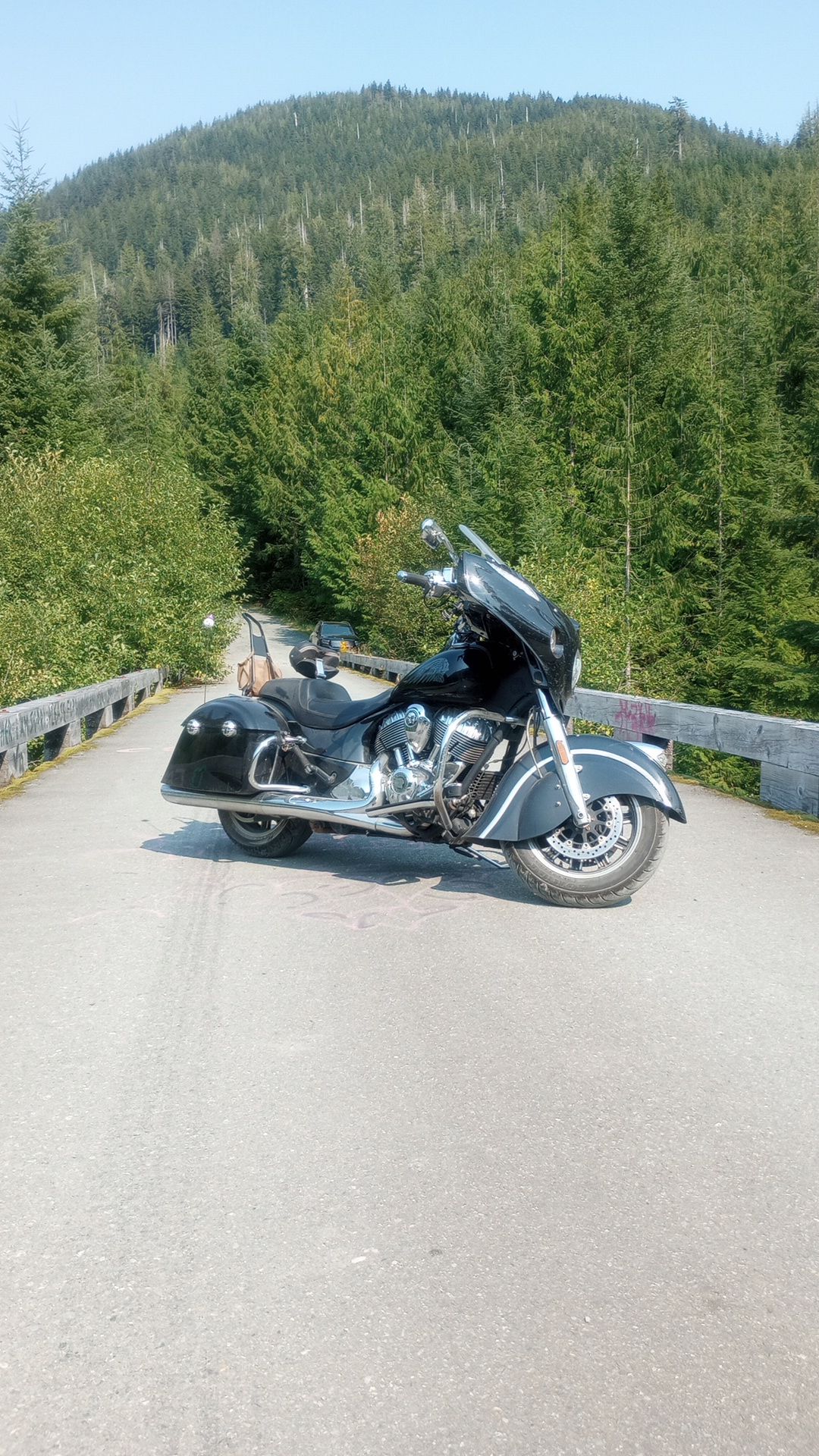
On the ride back down I stopped at some of the bridges, because they were serious effort for such a remote area. They were steel but the roadbed was wood, and the railings on the side weren’t even knee high. Useful for keeping cars from driving off the edge but useless for a guy on an 850lbs motorcycle.
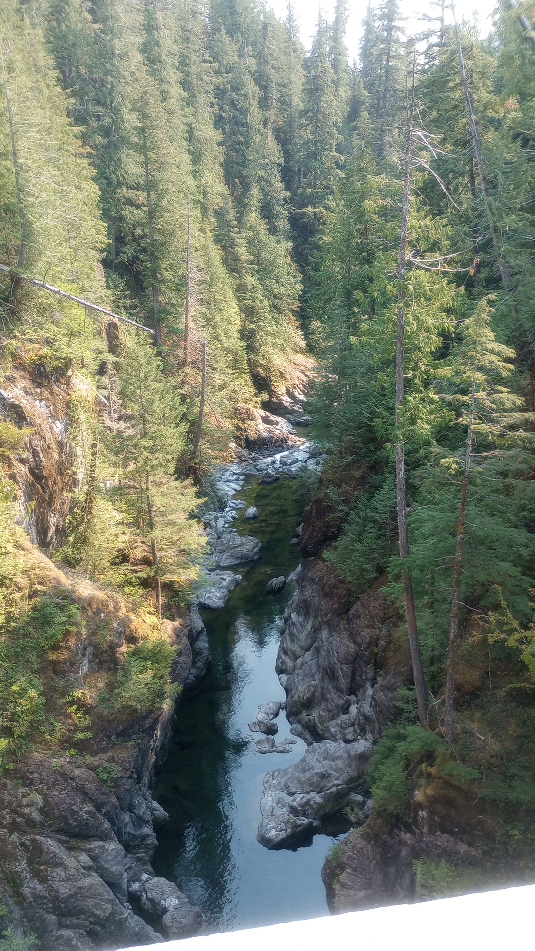
The biggest one was several hundred feet high, crossing a deep canyon. Someone had put a suicide note as graffiti on one of the rails, asking their mother for forgiveness. It was really sad, but when I looked that night I couldn’t find anything about that bridge being linked to any suicides.
I also noticed a bridge of a different kind paralleling one that I was on, and was able to take a closer look. It was all wood and clearly very old and long abandoned. It seemed it must have been used for railroad based on how big its main pilings were, but there was no evidence of rails. The entire roadway was blanketed in moss.
Despite the thickness of the beams, they were soaked and had an appearance of cork or shredded wheat. A tree had fallen on one section and totally wiped it out. The bridge was clearly several hundred feel long, which made sense considering the current bridge was long enough to cross the river, its flood plane, and some marshy land.


I eventually had to move on, but did have one great night hanging out with fellow campers. Canadians seem to be able to talk about politics and religion without getting angry, so we were able to chat for hours about indigenous rights, marijuana laws, abstract theories about the existence of god or the nature of humankind, and do it while sipping beers and enjoying the waves crashing on the shore and the crackle of a campfire.

On the road again I moved along Hwy 14, which follows the coastline more or less, along the southern shore of the island. I enjoyed this ride possibly more than any other section of road since I got off the ferry. There were very rough patches and a lot of “tree tunnel” effect, along with coastal fog restricting the views I did get.
There were still plenty of views, light traffic for most of it, and it wasn’t terribly cold despite being foggy. I took Hwy 14 to Sooke, which is a lot smaller than the map makes it look. I got a great American-style breakfast for lunch and hit up the Sooke River Campground, where I booked two nights.
It rained quite a bit overnight but there was enough sun to mostly dry things out before I had to pack them. I didn’t really explore the town because around 230pm it was beset by traffic on the highway, as it was the only road through town and had two schools and a large shopping center on it, making for a lot of traffic coming in and out, as well as through.

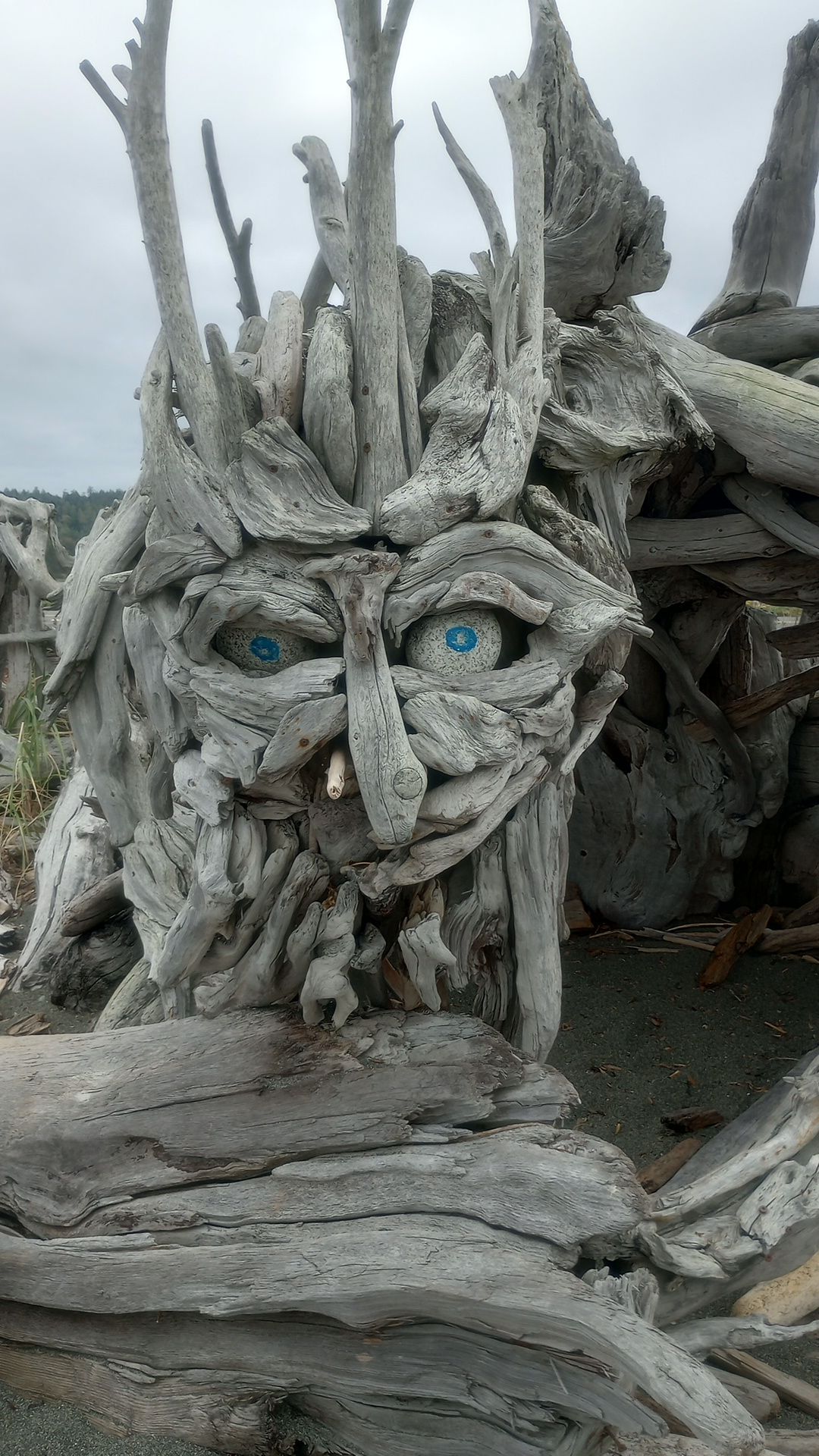
I used the time to watch ducks and geese and even a seal enjoy the river, did some reading, and booked another campsite at the spot I first camped at when arriving on Vancouver Island. I tried to explore Victoria on the way up, but just couldn’t deal with the crowded feeling. I stopped at one area to check out some found-art sculptures made on a driftwood beach though.
That spot was quiet and the stillness juxtaposed well with the crowded shoreline in the distance, full of marinas and breakwaters and industry.


Once up in Sidney again I set up camp and another wave of lethargy came my way. I just didn’t have any desire to do ANYTHING at all, and rain came in to make sure there wasn’t anything I could do even if I did get out of this funk. I did some more reading, and found breaks in the rain to go out for dinner and even some easy-to-make groceries (no one wants to stand in a cold rain while cooking).
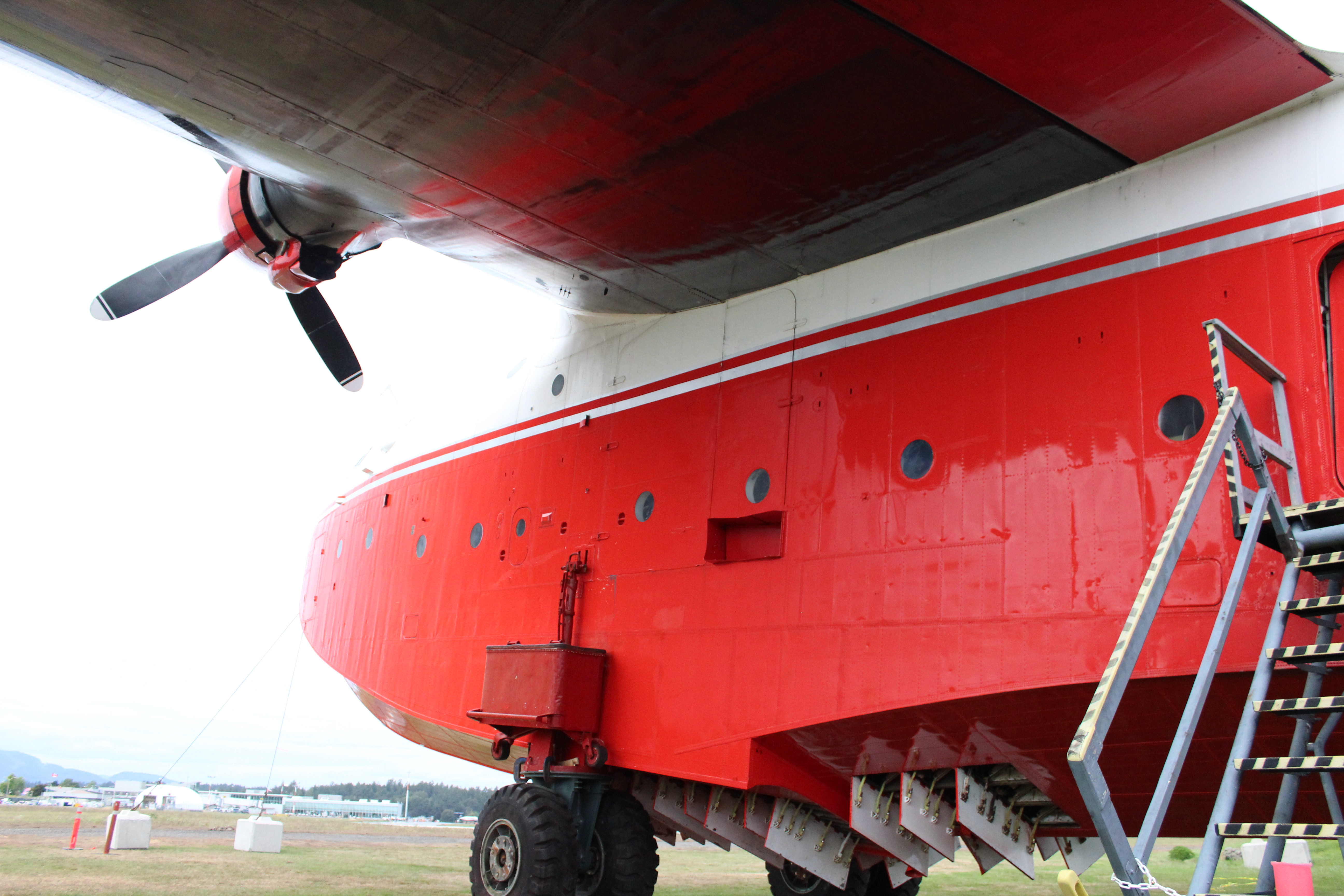
I did make it to the BCAM (British Columbia Aviation Museum) to see the Mars now that it is parked on shore. The museum itself already had an entire section on aerial firefighting and had photos and old parts from Mars, so it was truly a fitting home for the plane now that it’s retired.
The museum had old floatplanes, artifacts from WW2, a few training planes that operated on the island back then, some 1950’s airliners, a few reproductions of WW1 aircraft, and some old radio equipment as well. They even had the remnants of one of the Japanese balloon bombs that were launched during WW2.

Outside Mars was clearly center stage. It’s over 4 stories tall when on its beaching gear, and it still bore the oil and exhaust streaks from its final flight. The water drop doors were open and airing out, and it still looks very much like a working aircraft and not a static display.
There were other firefighters there including a fellow WW2 veteran like Mars. Though much smaller, the A-26 Invader was a popular plane for water bombing because it was fast and light, and was designed for ground attack which requires agility at low altitude.

After the museum though there was a lot of trying not to get wet, drinking out of sheer boredom, and some aborted attempts to hop on the ferry. I eventually decided to make a loop up to Prince George and back down to visit with my friend Brock. It was convenient that he was also a fabricator, as I needed to do some work on my trailer which will require welding.
I’ll aim for another update before I cross into the US again, but it depends on finding the time and energy, at the same time. The plan does still remain the same though: see the Spruce Goose in Oregon, work south through central Oregon to my storage unit, and either trip down the CA coast of the Sierras, out-running any impending fall weather. During that time I’ll need to make a plan for where I’ll winter, but I have a few ideas already.
Until next time..
