Since it will be awhile before I can do another update, let me share some pictures of the motorcycle trip through Washington an my final slice of British Columbia now, so we aren’t overwhelmed with pictures for the next update. As I said in my last post, weather knocked down enough trees to delay my reentry to the US, but I used the time to make updates and do a little planning ahead.
Usually I only plan 1-2 days ahead because things change on the road: you stop more often than you think, you find a detour to try out, a lane closure adds an hour to your day, or you just don’t feel like packing up the tent and decide to stay an extra night somewhere. Being more fluid and having little expectation is a great way to make sure you are always pleasantly surprised.
Waiting an extra day in Greenwood let me catch up on things and also poke around the small but historic town. One oddity was a tunnel without a mountain. I’ve seen filled in or collapsed tunnels, but I’ve never seen a tunnel left in place while the earth around it was removed.

The reason was sensible though. The old rail trestle collapsed and was replaced with raised earth, so they put in a single-lane tunnel. Traffic demands called for a 2-lane tunnel so it was added later and the single-lane was left abandoned. When the railway was removed, the fill dirt was needed elsewhere, so the 2-lane tunnel was blasted away to clear the highway and the single-lane tunnel was left in place since there was no need to remove it.
The town also has a history with timber and power generation, but remains a quiet throwback to another time, with only a few hundred residents now.

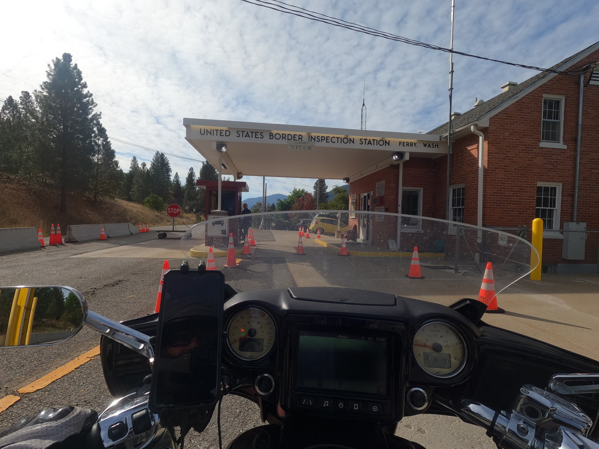
Coming to America
Crossing to the US was easy enough. Midway is a smaller town than Greenwood, and the Canadian side wasn’t even open. On the US side, it was just one guy and I was the only vehicle. I answered the obvious stuff about who/what/when and off I went. My first stop was the smallest state park in America: the gravestie of Ranald MacDonald.


No sense in rehashing his history here, the internet has plenty. In short, he left a boring office job to sail the seven seas, eventually choosing to fake a shipwreck so he could land in Japan, which was still closed to all foreigners. He was imprisoned but eventually befriended guards and taught several English.
The grave is in a very small cemetery adjacent to a farmer’s field and little else, but it was near where he passed away, being cared for by family as his health failed in his final months.
Towards AND away
I don’t know what changed other than my attitude. The terrain was no different being on this side of the border, but my eyes were absorbing things. I wasn’t just passing through: I was part of the landscape. The low hills looked closer, the rivers looked deeper, the old buildings looked to be telling their story more loudly.


Sometimes your mind is just more “in tune” to the road and the world we are moving through, and this was one of those days. I felt the full blessing of being on the road, in the sun, on my own, and with no immediate worries. It was freeing to slow way down and putter along empty roads, looking at each valley or lake keenly, and not just with a mild interest.
My next destination was the town of Cheesaw, which likely has a population of less than 100. It was important during the mining boom, and was named after a Chinese immigrant who settled the area before miners came through, named Chee Saw. He owned several businesses serving the miners of the area but things of course came to an end. Now the town is generally known for a July 4th rodeo and little else.
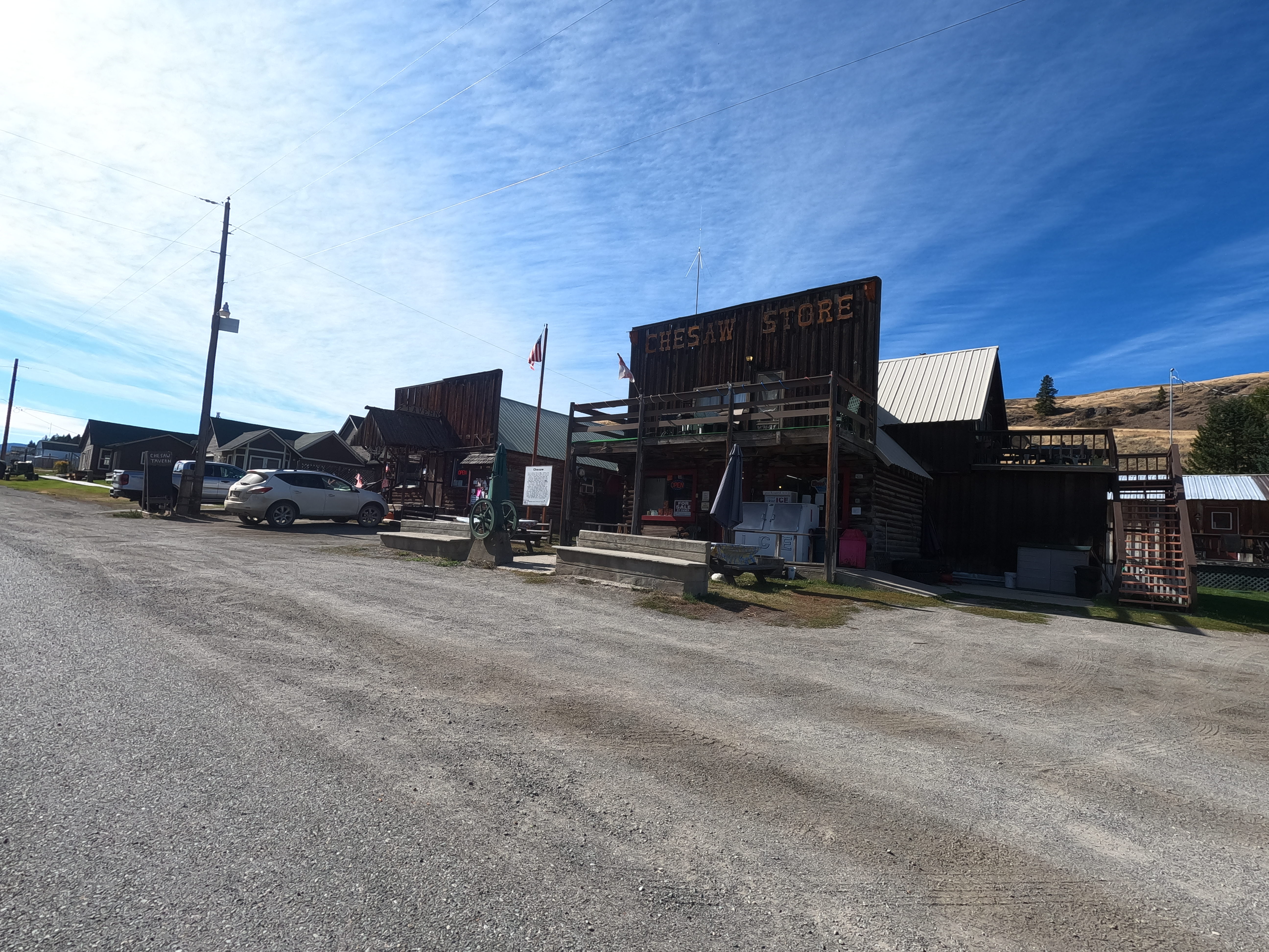
It’s still popular with motorcyclists though because the road into town from both directions is beautiful. I ate lunch and had a beer at the Cheesaw Tavern, took a few photos, and was on my way west, and south. Things started to open up more, with the valleys and hills being covered with brown grass more than pine trees. Not desert yet, but certainly not forested.
I made a quick stop at the Hee-Hee Stone, or its former location. Natives said the stone was a woman who was turned to stone and was left there to care for those passing through by granting wishes. In the early 1900’s either drunken miners or a landowner who thought something was hidden inside dynamited the stone.
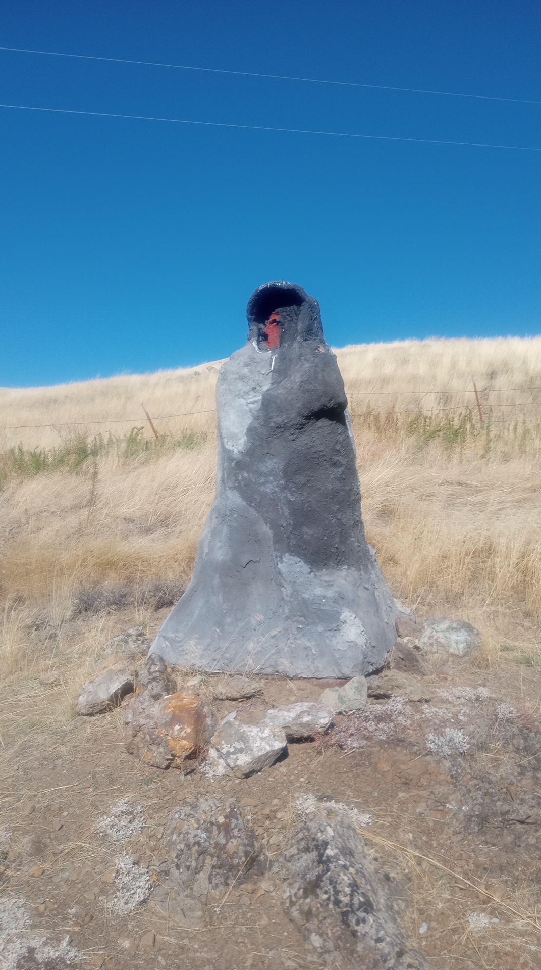
Natives restacked the rocks but there is nothing really left now but a few low stones and a plaster replica. People still leave trinkets and other offerings and make wishes at the spot.
The ride south definitely became flatter and more brown, but there were still stands of trees here and there, along with rivers to add some green to the horizon. I picked up Hwy 97 and took it to Yakima, where a state park had surprisingly quiet sites for being so close to town. I spent the night peacefully and started following the Columbia River towards Portland.
In The Dalles I grabbed lunch and went to the National Neon Sign Museum. It was a private collection and the owner acted as the tour guide. From the beginnings of harnessing neon for light to the heyday of the 1950’s, there were some nice displays. The Dalles is another historic town and the museum is the old Elks lodge, from 1913 I think.


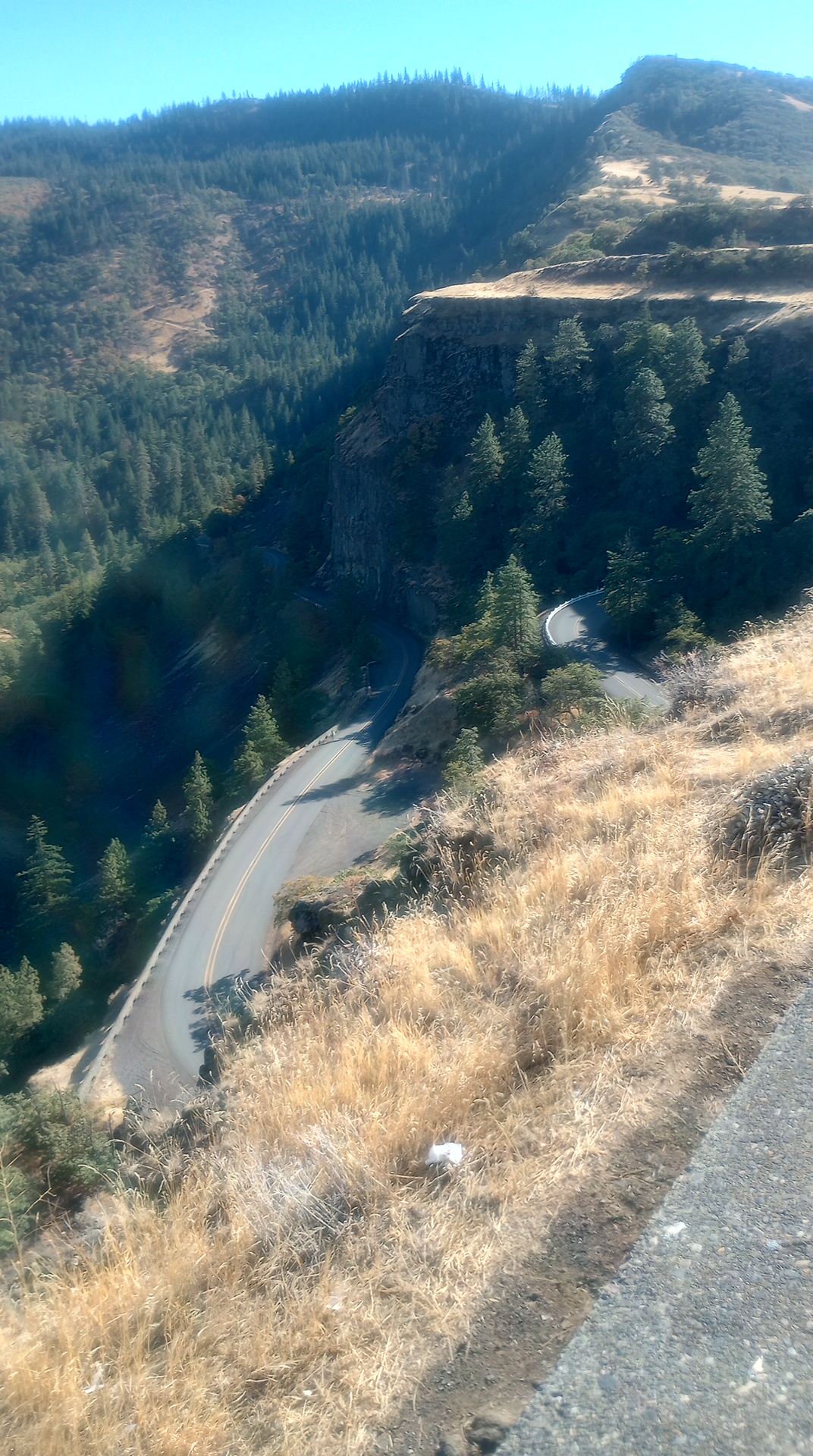
Old Hwy 30 spread off the interstate and was a great distraction, weaving back and forth in the style of that bygone era when steam shovels couldn’t level entire mountains so the roads had to wind their way through the terrain, instead of flattening the terrain to make the road.

I also saw Memaloose Island, which apparently was used by natives as a burial ground. Rumors of haunting were interesting, but the above-ground burial sites are long gone other than a single memorial cross of some kind and a few signs on the edges of the island, used as navigation aids for ships during bad weather.
Eventually the Interstate gave way to traffic, as cities often do. I was able to stay with a friend though who lived in the NE corner, which was the side I was approaching, so I was able to avoid most of it. I had only planned to stay two nights, but here on day six I’m finally about to pack up and head to see the Spruce Goose: the unofficial “last stop” on my trip.
In actuality though I have about 1,900 miles to go and plenty more to see, but the official goal of checking out seaplanes and aviation museums was going to end with the “big dog” of all flying boats. I still have some hikes to take, some mountains to see, a few locations to revisit from my 2020 trip during COVID when everything was closed, and a few more friends to stop off and see.

Clearly though, based on being here in Portland for too long, I can tell my mojo is depleted. I like being on the road but usually around the 4mo mark I get sick of packing and unpacking, just like after about 4mo of being stationary has me opening maps and planning my next trip, because I’m stick of washing the same dishes and sleeping in the same bad.
The grass is always greener, but I’ll try to find more of that special connection I found when I crossed back into the US. Perspective is the lens by which we understand our reality, but travel is only good for perspective if you’re paying attention. Life on autopilot teaches us very little, whether we are sitting in a familiar spot or out in wildly foreign or untamed lands.
